Tuesday, March 18, 2014

ECOLOGY OF MEXICO 2014, BY CITLALI REYES

                                         States of Mexico

The geographic characteristics on Mexico consist into 31 states and 1 Federal Distric.
Figure 1. Map of Mexico within its states.  Source by Pin Mapa de Los Cayos.

Biomes Present in Mexico

The map below was made by Citlali Reyes according to data obtained from a website called "Biomes and Latin Americans". According to the skecth showed in that website, there are three biomes present in Mexico. The Chaparral and Desert Biome continue up to the U.S., while the Temperate Rain Foresr biome goes down to Belize, Guatenala, and the rest of Central America. I need to mention that this information may differ form other sources, I wrote Temperate Rain Forest because that was exactly the expression on my source, but below I write about Tropical Rain Forest because that's the information I found about.

Figure 1. Map of Biomes in Mexico

Biomes Characteristics in Mexico

Desert

According to the NASA Earth Observatory, the average temperature in the Desert goes from 38°C during the day, and -3.9°C during the night. The precipitation average is about 250mm of rain per year. 


Chaparral

The Chaparral Biome is also known as shrubland biome, its temperature range goes from 30°F in the Winter time and it can be up to 100°during the summer. The average temperature in this area is 64°C. The precipitation is from 10 to 17 in per year.  The data was collected from Bioexpediton.com in its publication called "Chaparral biome". 


Tropical Rain Forest

Even though in the map is written as Temperate Rain Forest, there was only information about tropical rain forest, which I assume may be another name for this type of biome. The temperature ranges of Rainforest goes from  20°C ( 68°F) to  34°C ( 93°F). For the other site, the annual precipitation is 100 inches normally (Michael G. 2001). The data presented was obatined in a article called Tropical Rainforest.


Highest and Smallest Elevation Points of Mexico

I made this map with images taken from Google Earth, and the data about these elevation points were found in a website called Index Mundi, CIA World FactBook, Dec. 06, 2013.

Figure 2. Location of the highest and lowest elevation point inMexico.

Santa Maria Zacatepec: Latitude and Longitude Coordinates

Latitude: 16°45'44.74'' N
Longitude: 97°59'25.72'' W

Data obtained from Google Earth webpage, in Santa Maria Zacatepec. Mexico

Mexican Principal Ecosystems

The map below shows the distribution of the main ecosystems in Mexico. The map was obtained from a article published by VivaNatura, click on this link to learn more about ecosystems in Mexico.

Figure 3. Map within Mexico's main ecosystems areas.

Images of Each Ecosystem in Mexico

The following images were obtained from a governmental website about biodiversity, and the images include a representative picture of how the area may look, plus some additional information.Click on Mexican Ecosystems to learn more about the images below.


Ecosystem in Santa Maria Zacatepec, Mexico.

My native community consist on mountains that surround it, an semi-urban community that make use of the rivers and the land. Is mostly conformed by deciduous and semi-deciduous forests at the bottom part of the montains such as coconut palms, huanacaste, and a variarity of fruit trees. Because Zacatepec is a 6 hours away from the Pacific Ocean the climate is mostly warm and hot, but in the last 5 years (from my personal experience, and others citizens comments) climate is on constant change, for example, in January was raining when actually the rainy season starts in August! 

There is not fish wildlife in the rivers of Zacatepec now days, and people like to consume animals such as iguana, deer, and fish such as srhimp, crab, etc. that are brought from other communities close by. 

Usually, during the rainy season (August-November more or less) we have storms, or strong rains. And about wildlife, specifically birds, people like to have as pets parakeets, which is sad because they are being threatened and sold to people at high prizes.

So, this is a short description about the ecosystem in my community Zacatepec (which actually means "Hill of Grass" in Tacuate, the native language there), the meaning is because the community used to look really dark green everywhere, and still look like that. 

List of Threatened Species in Zacatepec, Mexico.

English Name                                Spanish Name                                               Scientific Name

Elephant ear tree                           Huanacaste, Parota                                    Enterolobium cyclocarpum
Montezuma cypress                       Ahuehuete                                                  Taxodium mucronatum
Armadillo                                       Armadillo                                                    Dasipodydae family
Iguana                                           Iguana                                                        Iguanidae Family


Map of Types of Soils in Mexico

The map below was obtained from Mapas de Mexico website.


References

Biomes and Native Americans, Author Unknown, year unknown. (http://www.homewood.k12.al.us/edgewood/staff/fwoodruff/biomes/biomes.html)

Monday, March 10, 2014

Lab No. 6 - Evolution and Adaptations


  1. Explain adaptive radiation and how the different paper forms made by “finches” helped or hurt that particular finch species.
          On last class, I learned that Charles Darwin collected birds that were very similar when he went on a trip. Even though these birds look a little different from each other, they came from the same family species. The reason why they became different was because they adapted for different diets: seeds, insects, flowers, etc. according to the different places they where at. When a family is separated from a phisically form of barrier and over a long period of time they adapt to different habitats until they become two different species, it is called adaptive radiation.


2. With the" prey" survival data you collect, graph survivorship over time by each species.


         3. Explain how behavioral adaptations may lead to genetic changes in a population.
         Depending on the ecosystem a individual lives, its instic may help to adapt not just to survive, also to mantain its species population. For example, if there is a family of birds that share the food from the same tree, if they all eat from the center of the tree, none fo them are going to survive, but the one that finds a way to adapt to another part of the tree, has more chances to survive. Animal species does not just need to be the strongest one, they also have to count on flexibility skills to survive by adapting to a new environment. The results of this type of adaptations over long periods of time may lead to evolution (which comes with genetics changes in a population aver million years).

4.  A species that has a behavioral adaptation that may allow its predator not to be able to eat it or find it. Explain what this behavioral adaption is.
       Behavioral adaptation refers to what an animal does, how it acts or response to something from the outside, its environment. For example, Shinook salmon from the Pacific Northwest that can migrate to colder waters in the ocean, live there for a while, adapt to the salty water to later on go back to the place they were born (up in rivers). 
Source:Bin Hen. Chinook Salmon. Lake Creek. Oregon Fish & Wildlife


 5. A species that has a physical characteristic that allows it to survive in cold weather.
   Deciduos trees can drop their leaves and stop to produce more leaves in winter, so they do not waste energy. In fact, they save enough energy so they can survive in cold temperatures.
Reyes, Citlali. Deciduos trees at Leach Botanical Garden.

6. An example of mutualism in nature. Explain what mutualism is this case.
   Mutualism is when to different species make a deal: they both share, both benefit from each other to survive. An example is a process called symbiosis, that is when fungi absorbs water and share it with a tree that does not have enough root hairs to reach water, while the tree produces sugar to feed itselff and the fungi.

Symbiosis between a tree and a mushrom

7. An example of commensalism in the nature. Explain how your picture represents commensalism.
A simple example of commensalism is a bird living on a tree, the bird has a place to live without harming or helping the tree. So, commensalism refers to a individual that obtains a benefit from another one, but without harming this other individual.
Reyes, Citlali. Bird observed during SEED students OR Trip
8. An example of mimicry in nature. Explain what the mimicry is this case.
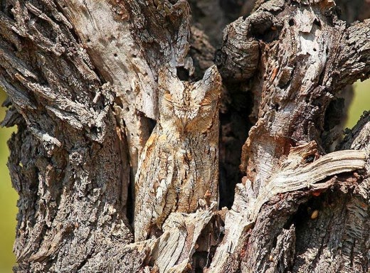
If you observe carefully in the image below, a owl looks really similar to the bark of that tree, this makes hard to see the owl, and hide him from another predator around there by using a type of camouflage. So, mimicry is the ability of the owl to look similar in appereance to the bark of that tree, which gives him an adventage to survive.

Mimicry performed by an owl, with a great camouflage of the tree bark.
 9. One species of insect from Mexico that has an adaptation to survive. Explain.
The Monarch Butterfly hibernate in Mexico during spring, then find a mate. Then they migrate north (U.S.) to lay their eggs. This is an adaptation to survice because they cannot survive in the North during the winter time, they look for warmer places such as Mexico.

Adult Monarch Butterflies


Saturday, March 1, 2014

Sunday, February 16, 2014

Lab No. 5: Germination and Productivity


Introduction

SEED students discussed about wheter or not a plant can germinate in the dark, based on this, raddish seeds were used to look for answers. Two containers with 36 plots each one were exposed to the sunlight, while other two cointainers were put in a dark closet for a couple fo weeks. This report pretends to show what was the general hypothesis, and the question to solve. Also will be showed the experiment students did, the data collected, and its steps.

  • Hypothesis
Seeds need light in order to germinate.

  • Question
 Can seeds germinate in the dark?


Part 1. Seed Germination

DATA FOR DARK TREATMENT GROUP

Step 1. Your group will receive a tray of 36 samples (6*6). Write down:

    a. How many seedlings germinated per sample? 50
    b. Number of seeds originally planted per sample: 144

Step 2. Now you can calculate the percent germination of the seeds.

% Germination=     (Total germinated seeds / Total planted seeds)  * (100)                                    
% Germination=     (50/144) * 100
% Germination=     34.7 ~ 35%

Part 2. Write this a s a blog entry. Please type a few sentences to answer each of these questions and turn them in.


    1. What was our CONTROL for this experiment?

Seedligns that growed on the light (because it is known that seeds can germinate on the light)

    2. What is the percent germination for the LIGHT TREATMENT? For the DARK TREATMENT?

        % Germination on Dark treatment:  34.7 ~ 35%
        % Germination on Light treatment:  47.9 ~ 48%

The data for the Germination of the light treatment was courtesy of Lilian Xitumul and the integrants of her team.

% GERMINATION GRAPH 


AVERAGE WEGHT GRAPH


AVERAGE HEIGHT GRAPH


Part 2. GPP and NPP


a. Record the weigth (mass) in grams of all the seedlings from your group.

8.9 grams

b. Place all your sprouts on a piece of aluminum foil so they are laying side by side (not mounded up in a pile). These group of plants were dry out for 5 minutes at a temperature of 400º F. After that, the weight was:
1.9 grams

GPP for the Dark treatment 

GPP before drying out the seedlings                      GPP after drying out the seedlings.

GPP = NPP + R                                                               GPP = NPP + R

GPP= 8.9 + 8.9                                                                GPP= 1.9 + 1.9

GPP = 17.8 grams                                                             GPP = 3.8 grams


                                                       GPP for the Dark treatment 

GPP before drying out the seedlings                      GPP after drying out the seedlings.

GPP = NPP + R                                                               GPP = NPP + R

GPP= 11.4+ 11.4                                                                GPP= 2.0 + 2.0

GPP = 22.8 grams                                                             GPP = 4.0 grams

Monday, February 3, 2014

Marmot Dam Field Trip

The Marmot dam was built by PGE (Portland General Electricity) in order to generate electricity, but after interrupting part of the Sandy River (which comes from Mt. Hood) for almost a century, the dam was destroyed in 2007 as an experimental procedure which has been observed and analyzed to gather information about its effects on its ecosystem. Another part of what I learned on this field trip, was that this really will help fish habitat (that used to migrate to the salty part of the water close to the beach) and other organisms to survive. Another reason why the dam was destroyed is because it was not worthy to maintain a dam that did not produce enough electricity as before, and also following the new and strict regulations made to protect salmon habitat, PGE would have to invest even more to help salmon migrate to the bottom of the river trough the dam; it just was too expensive, so the dam was destroyed.

U.S. Geological Survey (USGS ), March 18, 2007. Marmot Dam

One of the concerns that environmental organizations and PGE had when they decided to destroy the dam, was that fish living downstream could be buried by all the sediment accumulated on the dam, so they collected wild salmon and save them on a hatchery and then released into the river after the dam was totally removed, this action protected fish population. About the amount of sediment accumulated, this did almost nothing. Thanks to storms, all the sand, gravel, etc. were digested quickly and it did not expand in a large area. Below you can observe a video about it.


After the demolition of the Marmot dam, PGE donated the land where the dam was to organizations that want to conserve and protect this land. In one side of the Sandy River, you can see how the trees look younger than the forested area from the other side. It also looks harvested because the area was used for logging. Now that this land is under protection, we can say that is going through a secondary succession process since the land was already there, the only thing people worked on was on applying fertilizers to improve soil quality in order to reforest the area with native trees (the area is starting to recover). Compared to the other side, I observed how it has a greener and forested place, there is mostly cedars and the ground has a thick layer of woody debris and really reddish and soft soil, which are great signals for a very good forest! 


Would things be the same as before? Who knows, but this is an important starting to care about nature, its course, its connectivity with everybody else. Human kind probably should leave nature as pure as possible I think, but unfortunately that is not realistic, neither possible, we need from natural resources. What we should learn is how to peacefully interact, and manage the natural resources in a sustainable way.

Monday, January 27, 2014

Lab No. 2 - Comparison between scientific and popular articles


A)  COMPARISON OF TWO PAIR ARTICLES (SCIENTIFIC AND POPULAR)

1.    Comparison between articles “A” & “B”.
The popular article (“B”) does not address everything what was wrote on the scientific one (“A”), because the scientific article talks about very specific research information on how rural out-migration in Mexico had affected the deforestation levels, agricultural intensification, and deforestation in the Neotropics (such as Mexico), it also gives a message (which I totally agree) that with social and government support, proper human development strategies involving the active participation or rural people Mexico’s society can face and reduce the deforestation levels. On the other side, the popular article pointed out what are the main factors of deforestation worldwide. However, both articles have something very important in common: Deforestation expansion as a negative cause of deforestation in many countries (Mexico as one them), mainly because of non-sustainable agriculture practices, and extensive use of grasslands for livestock.

2.    Comparison between articles “C” & “D”.
The popular article (“D”) address very accurately the science article (“C”) about the oil spill happened in April, 2010 in the Gulf of Mexico. The popular article summarized and clearly explained the data on the scientific article: This was a tremendous oil spill (notice that nearly 5 million barrels (210 million gallons) of oil spewed), “the oil spill and plume covered nearly 360 square miles, about the size of Dallas, Texas”- according to the research article. The task that the first researches had was to investigate what were the results/impact that this event caused on the deep-sea ecosystem and the natural resources around the area. Even though part of “the oil was removed by cleanup operations and other natural mechanisms it is estimated that 35% of hydrocarbons from the oil were trapped” in the surface and deep sea and devastating the biodiversity of the Gulf of Mexico. Sadly, the recovery rates in the deep sea are likely to be slow, on the order of decades or longer.


B) SCIENCE ARTICLE ANALYSIS (ARTICLE “A”)

What this a controlled experiment? Yes.
What was the control?
Tables and graphs that provided analysis of deforestation rates in relationship to percentage of population.
What were the hypotheses of the experiment?
One of the theories the article showed was that the agriculture’s out-migration from Mexico caused the abandonment of agricultural production which in turn, became one of the main causes of recovery of forested areas.
Did the data support the hypothesis (hypotheses)?
NO, according to the research that the authors did, people migrating to the U.S. is a response to rural and urban unemployment, and once they save enough money they invest in livestock and sell their grasslands to bigger farmers that keep expanding agriculture (without applying sustainability). As mentioned on this article: “Expansion of agriculture is the largest driver of deforestation in underdeveloped tropical countries”, such as Mexico.
Were the methods repeatable?
Yes, the data provided by the tables on the article were obtained from 10 to 15 case studies (some of them went from 1986 to 2000) analyzed by Galvan and colleagues (2009).
Was there adequate replication?
Yes, on page 869 was showed a brief description of two cases derived from their own field research, in which neoliberal policies propelled significant land-use change by inducing international migration and discouraging or outcompeting small-farmer maize production.
Was there a founding source to that may be a conflict of interest?
This research project was funded by the Consejo Nacional de Ciencia y Tecnologia (projects 51253 and 45636) and by the University of California Institute for Mexico and the United States program (2008-2009).


Saturday, January 25, 2014

Lab 3: My Tropical Ecology Blog!


  • What am I excited about learning in my tropical ecology class?
Biomes and ecosystems in Mexico, the root causes and effects that population growth and human actions are creating on our Natural Resources, and how can I clearly inform people in a crearly way. How the different ecosystems in Mexico act, how large is the damage they've had, and how can people repair such harm.
  • What is one of the main environmental issues your community experiences?
Water shortage is a major issue in Santa Maria Zacatepec, Oaxaca, Mexico.  The lack of sustainable agriculture harms the environment by excessive consuming rivers, lakes and underground water sources dry. "Inefficient food production and harmful agriculture subsidies are causing deforestation, water shortages and pollution" - according to the World Wildlife Fund (WWF). Economic diversity which leads to deforestation and the depletion of natural resources, affecting water availability and contributing to  climate change. The entire community of Zacatepec is affected by the water shortage which has resulted in the increase in cost for drinkable water, and has negative effects on farming practices and wildlife habitat; therefore, all people in Zacatepec are affected directly or indirectly. All the causes are connected because all of them need to have an organized and appropriate management.
  • What things have you learned thus far to help improve the environmental conditions of your community?
That there are connections between populations of different species of animals, plants, etc. therefore, when human activities interfer somehow in this natural cycle, the results can be really huge and negative. 

This video showcases Mexico's people and varied landscapes. The key message is that by acting now, we can protect the country's natural resources before they disappear, weave together a better future for people and nature and leave a lasting legacy for generations to come - The Nature Conservancy, 2010.

NOTE: For this specific website, you must click on the images to navigate into another webpages (the links were put in the images, not the words or sentences)